Haystacks
OS grid ref:- NY 193131
 Haystacks, an impressive and inspiring fell and a great favourite of guide book author Alfred Wainwright, is situated at the south-eastern end of the Buttermere Valley and rises to a modest 1,958 feet (597 metres). The curious name is said to derive from the appearance of the summit cliffs. According to Wainwright, the name comes from the Icelandic word stack meaning 'a columnar rock' and the correct translation should therefore be High Rocks.
Haystacks summit has a profusion of small pools, tarns and marshland. The highest tarn is just below the top, generally referred to as the summit tarn but officially unnamed. Halfway along the ridge is Innominate Tarn, a popular beauty spot with an indented rocky shore and a line of tiny islets. At the eastern end is Blackbeck Tarn, a long narrow pool which overflows through a cleft in the crags.
Wainwright failed to mention the fell as a whole in his "best half-dozen" at the end of his "Pictorial Guide to the Lakeland Fells" because of itsinferior height, but stated that " for beauty, variety and interesting detail, for sheer fascination and unique individuality, the summit area of Haystacks is supreme. This is in fact the best fell-top of all."
The fell's main claim to fame remain its connections to Wainwright, the author's ashes were scattered by his wife Betty near the shores of Innominate Tarn. In nearby St. James' church, Buttermere there is a memorial to him, situated beneath a window that looks out over Haystacks.
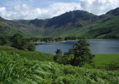
Views from the summit take in Gable Crag on Great Gable and the western panorama of Ennerdale Water and High Crag. Crummock Water and Buttermere are also seen.
Haystacks from Buttermere
Distance - Around 8 miles
*Commencing at the National Trust car park, just west of Buttermere village, turn right on leaving the car park and walk toward Buttermere village. After the road crosses a beck, turn right, onto the road that leads to a further car park. At a fork in the road, take the left fork, leading down to Buttermere.At a point where the track splits in two, take the left hand branch and proceed along it down to the lake shore.
*On reaching the lake, turn right and continue towards the stream which connects Buttermere and Crummock Water, cross the stream and follow the path as it enters the woodland. Continue on this track as it emerges from the woods until, near to the end of the lake a path diverges to the right, and climbs diagonally up the hillside heading for Scarth Gap. Take this path, and follow it for approx 1 mile.
*On reaching the top of the pass the path crosses another path than runs along the ridge line from High Crags to Haystacks. Turn left, and follow this path as it climbs up the western face of the fell. Follow the track along the summit of the fell passing to the left of Innominate Tarn before dropping down to Blackbeck Tarn.
*Retrace your steps to return.