A Short History of Cumbria
Prehistoric Lakeland
Mesolithic peoples inhabited the coastal areas of the Lake District from around 5,500B.C., when the felling of the primeval forest first began. At this time the Lake District was thickly forested, mixed oak woodland blanketed the valleys while the upper fells were clothed in pine and birch woodland, with only the summits projecting through the dense forest cover. The earliest evidence of these peoples is mainly in the form of animal bone finds and stone tools in the caves they once inhabited.
The arrival of Neolithic people saw the introduction of farming into the landscape. The area's mountains became the source of stone for 'axes factories' such as the four thousand year old axe quarry which stands on the heights of Pike o' Stickle, located on the scree slope on the steep southern side of the fell. It is one of the most important prehistoric axe factories in Europe. Axe heads from this location have been found all over England and in Northern Ireland.
Long Meg Stone Circle, Little Salkeld
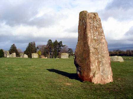
Many of the Lake District's Stone Circles, such as Castlerigg, near Keswick,Mayburgh, and Long Meg at Salkeld, appeared during the Bronze Age. Many theories exist as to their purpose, suggestions vary from astronomical clocks, or religious centres to trading places. The arrival of the Iron Age saw the introduction of improved technology, which accelerated the clearance of the forests. Defensive hill forts, such as that which can be seen at Castle Crag, Borrowdale, began to be constructed.
King Arthur's Round Table, Penrith
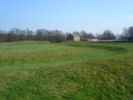
There remains much evidence of Iron Age settlement in Cumbria, with hill forts, such as that at at Dunmallard Hill, near Pooley Bridge, Ullswater. The remains at Dumallard are impressive, with a deep ditch and ramparts. The small fort covers about 1.5 acres and contains the remains of dwellings.
The Romans
Following the Roman conquest of England in 43 AD Cumbria remained independent of Roman rule for some time.The Romans marched their armies into Cumbria under Julius Agricola in 79 A.D., and subjugated the native Celtic Brigantes tribes, conquering the whole of the territory.
Establishing a fort at Watercrook, near Kendal, they built a road to the naval base at Ravenglass, over the high fells of Wrynose and Hardknott passes. Cohort forts were built along the road to control and dominate the area and strengthen lines of communication. The vast Hard Knott Roman Fort, or Mediobocdum as it was known to the Romans, stands on a bleak plateau, commanding a strategic position below Hard Knott Pass covering three acres.
Hardknott Roman Fort
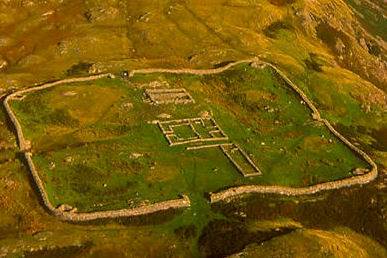
The Fort was built by the Emperor Hadrian and was quite extensive with granaries, bathhouses and a commanders quarters. Its walls were in the region of twelve feet thick. Some of the buildings have now been re-constructed from the original fallen stone.
Hadrian's Wall, built on the orders of the Emperor Hadrian, construction of the wall began after a visit by him to Britain in 122 AD and was completed about eight years later. By this time the Roman Empire had ceased to expand and Emperor was eager to safeguard its boundaries. The wall was constructed of stone and turf. At first built ten Roman feet wide, and later eight. It ran for 73 miles ( 117km) from Bowness on the Solway Firth across the country to Wallsend on the Tyne estuary. It provided a secure northern frontier to the Empire and kept the Celtic Brigantes to the South and the northern Picts and Scots firmly under control.
There are several forts and milecastles, small fortlets which were built every Roman mile (1,620 yards) along the length of the Wall, for its entire length, the largest is that at Birdoswald. Civilian settlements grew up alonside these military bases, among them the city of Luguvalium, now Carlisle.
The Celts
After the fall of the Roman Empire in the late fourth century A.D. , the Celtic peoples of the area gave themselves the name 'Combrogi' or ' Cymri', meaning 'Fellow Countrymen', from which the county name Cumbria, derives. In the sixth century Urien, son of Cynfarch Oer became the ruler of the kingdom of Rheged, the boundaries of which were roughly equivelant to the boundaries of modern Cumbria and Dumfrieshire, but included parts of Yorkshire. Nennius records his victories over the Anglian sub kings of Bernicia in the second half of the sixth century. The Historia Brittonum records that he was assassinated on the orders of his ally Morcant Bulc who resented his success.
Bernicia united with the kingdom of Deira to form the kingdom of Northumbria , before 730A Celtic Rheged was annexed to Northumbria. The alliance was cemented by the marriage of the future Oswy of Northumbria and a princess of Rheged. The Cumbric language then gradually became replaced by Anglo-Saxon. Long fallen out of use in other parts of England, many of the old Celtic place names have survived in the north west. The names of such familiar Lake District fells as Blencathra and Helvellyn derive from the Celtic language. The Cumbrian Celtic language, a form of Brythonic Celtic which was similar to Welsh and Cornish and known as Cumbric, died out in the area in the Middle Ages. Its last vestiges survived into the twentieth century as folk memories of Celtic numbers used by Cumbrian shepherds for counting sheep. Although long extinct, reconstructions of the Cumbric language are currently being attempted
The 7th - 10th centuries saw rival claims from Scottish and Anglo-Saxon kings for sovereignty over much of Cumbria. This internecine warfare culminated in the death or exile of Dunmail, the last of the Celtic Kings, after loosing in battle against the Saxon King Edmund I, in 945. The battle took place on the mountains near Grasmere. Following the defeat, the area was ceded to the Scottish crown.
The Vikings
The Vikings began raids on Britain in the eighth century. The Cumbria area later underwent further settlement by succesive waves of Anglo-Saxon and Viking peoples. The Lake District Vikings came from Western Norway, via Scotland, Ireland and the Isle of Mann. Arriving around the south west of the area they gradually penetrated into the uplands of the central region. The pattern of small farmers that became established in the area has its origins in Norse traditions, as does the practice of dividing holdings with drystone walls.
The Vikings bestowed on the area many of its distinctively Norse place names. Streams are termed becks, from the Norse 'bekr', waterfalls are forces from the Norse 'foss', 'thorpe', a hamlet, fell derives from "fjall" the Norse word for hill, and small lakes are termed tarns which derives from 'tjorn'. 'Thwaite' in Old Norse means clearing and 'saeter' summer pastures.
The Viking influence lingered in the isolated backwater of the Lake District until the Middle Ages. A Norse-English mixture of languages continued to be spoken there until at least the 12th Century . A Viking political system is displayed in the existence of several Thing mounds throughout the area.
Cumbria in the Middle Ages
Cumbria came under Scottish rule until 1072, when England's second Norman King, William II, 'Rufus' took Carlisle, settling the town with his Norman followers. He found the old Roman fortress there in ruins and established Carlisle Castle to guard the frontier in 1092. The town was retaken by David I, King of Scots in 1136. Cumbria was again returned to English sovereignty in 1157 by Malcom IV of Scotland, known as 'the Maiden'.
Shap Abbey
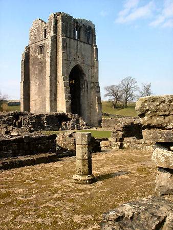
Most of the major Cumbrian monasteries, such as Furness Abbey, were founded in the Middle Ages and came to own vast tracts of land in the region. Throughout its history the area has witnessed fierce border raids by the Scots. After the Battle of Bannockburn, the Scots, under Robert the Bruce, descended in fury, ravaging and burning Carlisle, Appleby and Penrith. Pele towers were constructed as a means of defence, those at Sizergh, Muncaster and Hutton were later to be developed into stately homes.
Medieval Pele Tower at Killington, East Cumbria
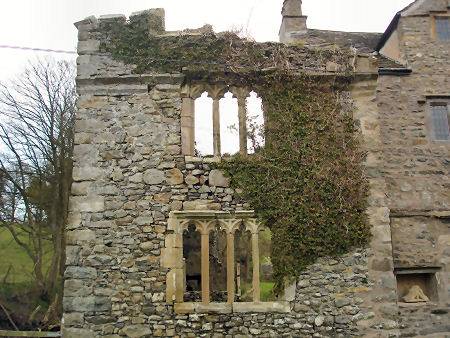
Border raiding was a common feature of life in the far north from the late middle ages to the end of the Elizabethan era and the accession of James VI of Scotland, son of Mary, Queen of Scots, to the English throne as James I in 1603, when the crowns of England and Scotland were united in his person.
The Victorian era
The advent of the railways in the eighteenth century brought rapid increase in tourism to the area and many industrtialists built mansions on the shores of Lake Windermere. The great Lake District poet, William Wordsworth strongly objected to the influx of tourists, feeling that they would have an adverse affect on the natural beauty of the area. The establishment of the railway was staunchly opposed by the poet.
Touring the Lake District was initially the preserve of the wealthy, but the arrival of the railways opened up the area to greater numbers of visitors from the industrialised areas of Manchester and Liverpool, meaning that Cumbria was no longer socialy and economically isolated from the rest of the country. The first line in the county linked Carlise and Newcastle in the 1830's.
Castles and Stately homes in Cumbria