Underbarrow
OS Grid ref:-SD4692
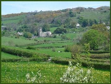 The pleasant Lakeland village of Underbarrow lies to the west of the town of Kendal and stands at the foot of Helsington Barrow, a limestone ridge rising to around 700 feet.
Underbarrow stands at the centre of a network of roads linking Kendal to Crosthwaite in the Lyth Valley, Newby Bridge and Ulverston and the village of Crook to Levens. Underbarrow is a characterful village and has a nucleus of old buildings standing at its centre.
All Saints church, which is situated at the northern end of the village, stands in a highly picturesque setting by fast flowing Chapel Beck. The church was constructed in 1869, but stands on a site that has been occupied by a place of worship for nearly a thousand years. The church chalice dates from 1609 and the church still retains its old oil lamps, which hang from the roof.
The village has one inn, the Punch Bowl, which dates to before 1660 and has a priesthole behind the bar. The pub, which is popular with walkers, boasts superb views, particularly of Helsington Barrow.
A circular walk from Underbarrow
Distance - 7 miles
*Commencing at the Punch Bowl inn at Underbarrow, turn right and proceed along the road for around 200 yards until reaching the driveway to Tranthwaite Hall on the left. Walk along the driveway (which is also a public footpath) for around a quarter of a mile. Just before reaching a cottage on the left, turn right, following the public footpath sign beside the kissing gate. Pass through the gate and walk up the field passing the waymarkers which are attached to pylons.On reaching the next waymark on a short post, bear right and proceed up the small knoll.
*Cross the field to reach a kissing gate and continue in the direction of the transmitter mast which is visible ahead. A line of waymarked posts leads to the corner of a field. Cross the farm driveway and pass through a gate to Gamblesmire Lane, a high hedged bridleway. Continue along the track, passing through woodland, pass through a gate and proceed on up the field keeping the wall on the right. Pass through a kissing gate to the left of the top wall. Turn left and walk along the line of the wall.
*Pass through a further kissing gate at Cunswick Hall Farm, walk across the field road and join the wall on the left for about 20 yards, pass through another kissing gate and turn right along the road. Cross a cattle grid and leaving the road to curve to the left, remain with the wall to the right. Continue passing a small wood.
*About 20 yards before reaching a second wood, look for a narrow gap stile, pass over it and follow the path through the woods, cross a stile, exiting the wood, turn left and proceed to a gate in the far right corner of the field. Pass through the gate toreach Cunswick Tarn. Continuie along the path between the woods and the tarn. climb a stile and bear left.
*Follow the ascending path through woodland, pass through a kissing gate at the top and turn right following the path. Remain following the wall and the edge of the wood as the path veers off to the left. At the end bear right around the corner of the wall to reach a footpath post. Continue to Scout Scar. Follow a second sign into woodland and keep to the right on encountering splits in the path.
*On arrival at a small car park in a quarry, turn right for a few yards then left at the kissing gate. Bear right and follow the path to the summit of Scout Scar. Proceed in a southerly direction along the edge of the scar, take the path that turns sharply to the right and continue through woods to join a track leading to a farm. Follow waymarkers to the rear of the farmyard. Pass through a gate, turn right toward Garth Row Lane at a signpost. Pass a farmhouse and turn left at the next signpost.
*Proceed down the field to the woods, climb over a stile and follow the path through the woods. Exit the wooods and cross the field heading to the right of the knoll. Turn right with the wall, follow the path beside a cottage, along a driveway to reach a minor road. Turn left and a few yards further on, turn right through a gate to a public footpath. After a few yards the wall bends left, at this point bear right and continue to the corner of the field. Cross a stile and head diagonally left across the next field. Cross a stile and a brook.
*Head slightly right in the direction of the pylon and cross a stile to arrive at a minor road. Turn left and follow the road past Tullythwaite Garth House, look for a footpath sign on the left but pointing right. Follow the driveway to an old garage and turn left, keeeping the old wall to your right and following the line of pylons. On arriving at a minor road turn right and continue along the road back into Underbarrow.