Logo
Home
Windermere East
Windermere West
Southern Verges
Cumbrian
Peninsulas

Langdale Area
Coniston Region
Wordsworth Country
Western Lakes
West Coast
Thirlmere Area
Derwentwater Area
Ullswater Area
Penrith region
North Cumbria
East Cumbria

Map & satellite
Wallpapers


Langdale

Blea Tarn
Cathedral Cave
Chapel Stile
Colwith Force
Dungeon Ghyll
Elterwater
Elterwater Village
Great Langdale
Garden at
Copt Howe

High Raise
Langdales
Langdale Boulders
Lingmoor Tarn
Little Langdale
Little Langdale Tarn
Little Langdale
Village

Skelwith Bridge
Skelwith Force
Stickle Tarn
Whorneyside Force

Lingmoor Tarn


OS Grid ref:- NY309032

Lingmoor Fell is a long wide ridge between the valleys of Great and Little Langdale and rises to 469 m (1,540 ft), its highest point is at its western end above Blea Tarn.

The fell's name derives from the Old Norse word lyng meaning "heather covered".

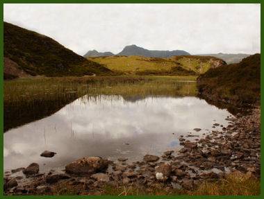
The small isolated tarn is around 200 metres in length and lies about 600 metres north of the summit. It is surrounded with rock and heather and has a few small islands within it. The tarn provides stunning views of the Langdale Pikes.

The approach via Elterwater is relatively easy and has good paths.